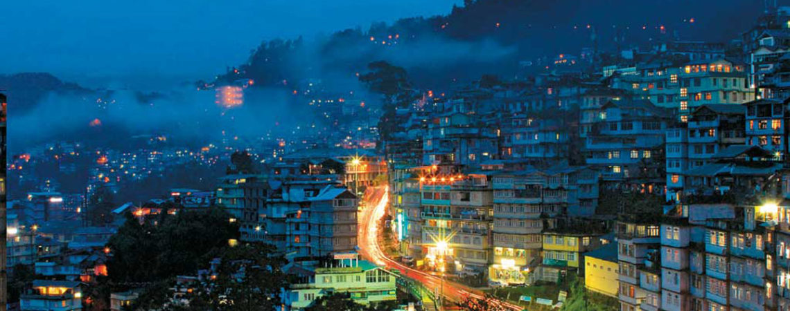
Gangtok is a municipality, the capital and the largest town of the Indian state of Sikkim. It also is the headquarters of the East Sikkim district. Gangtok is located in the eastern Himalayan range, at an elevation of 1,650 m (5,410 ft). The town’s population of 100,000 belongs to different ethnicities such as Nepalis, Lepchas and Bhutia. Nestled within higher peaks of the Himalaya and enjoying a year-round mild temperate climate, Gangtok is at the centre of Sikkim’s tourism industry.
Gangtok rose to prominence as a popular Buddhist pilgrimage site after the construction of the Enchey Monastery in 1840. In 1894, the ruling Sikkimese Chogyal, Thutob Namgyal, transferred the capital to Gangtok. In the early 20th century, Gangtok became a major stopover on the trade route between Lhasa in Tibet and cities such as Kolkata (then Calcutta) in British India. After India won its independence from Britain in 1947, Sikkim chose to remain an independent monarchy, with Gangtok as its capital. In 1975, after the integration with the union of India, Gangtok was made India’s 22nd state capital.
The precise meaning of the name “Gangtok” is unclear, though the most popular meaning is “hill cut”. Today, Gangtok is a centre of Tibetan Buddhist culture and learning, with the presence of several monasteries, religious educational institutions, and centres for Tibetology.
Like the rest of Sikkim, not much is known about the early history of Gangtok. The earliest records date from the construction of the hermitic Gangtok monastery in 1716. Gangtok remained a small hamlet until the construction of the Enchey Monastery in 1840 made it a pilgrimage center. It became the capital of what was left of Sikkim after an English conquest in the mid-19th century in response to a hostage crisis. After the defeat of the Tibetans by the British, Gangtok became a major stopover in the trade between Tibet and British India at the end of the 19th century. Most of the roads and the telegraph in the area were built during this time.
In 1894, Thutob Namgyal, the Sikkimese monarch under British rule, shifted the capital from Tumlong to Gangtok, increasing the city’s importance. A new grand palace along with other state buildings was built in the new capital. Following India’s independencein 1947, Sikkim became a nation-state with Gangtok as its capital. Sikkim came under the suzerainty of India, with the condition that it would retain its independence, by the treaty signed between the Chogyal and the then Indian Prime Minister Jawaharlal Nehru.This pact gave the Indians control of external affairs on behalf of Sikkimese. Trade between India and Tibet continued to flourish through the Nathula and Jelepla passes, offshoots of the ancient Silk Road near Gangtok. These border passes were sealed after the Sino-Indian War in 1962, which deprived Gangtok of its trading business. The Nathula pass was finally opened for limited trade in 2006, fuelling hopes of economic boom.
In 1975, after years of political uncertainty and struggle, including riots, the monarchy was abrogated and Sikkim became India’s twenty-second state, with Gangtok as its capital after a referendum. Gangtok has witnessed annual landslides, resulting in loss of life and damage to property. The largest disaster occurred in June 1997, when 38 were killed and hundreds of buildings were destroyed.
Gangtok is the main base for Sikkim tourism. Summer and spring seasons are the most popular tourist seasons. Many of Gangtok’s residents are employed directly and indirectly in the tourism industry, with many residents owning and working in hotels and restaurants.
MG Marg (Road) is one of the main shopping and cultural activity streets in Gangtok
Ecotourism has emerged as an important economic activity in the region which includes trekking, mountaineering, river rafting and other nature oriented activities.
The Nathula Pass, located about 50 km (31 mi) from Gangtok, used to be the primary route of the wool, fur and spice trade with Tibet and spurred economic growth for Gangtok till the mid-20th century. In 1962, after the border was closed during the Sino-Indian War, Gangtok fell into recession. The pass was reopened in 2006 and trade through the pass is expected to boost the economy of Gangtok. The Sikkim government is keen to open a Lhasa–Gangtok bus service via Nathula pass. Sikkim’s mountainous terrain results in the lack of train or air links, limiting the area’s potential for rapid industrial development. The government is the largest employer in the city, both directly and as contractors.
Gangtok’s economy does not have a large manufacturing base, but has a thriving Cottage industry in watch-making, country-made alcohol
and handicrafts. Among the handicrafts are the handmade paper industry made from various vegetable fibers or cotton rags. The main market in Gangtok provides many of the state’s rural residents a place to offer their produce during the harvest seasons. The majority of the private business community is made up of Marwaris and Biharis. As part of Sikkim, Gangtok enjoys the status of being an income-tax free region as per the state’s 1948 Income tax law. As Sikkim is a frontier state, the Indian army maintains a large presence in the vicinity of Gangtok. This leads to a population of semi-permanent residents who bring money into the local economy.
Indian publishing company Thomson Digital opened its production unit in Gangtok in 2013, becoming the first multinational corporation to maintain a presence in the city.
A centre of Buddhist learning and culture, Gangtok’s most notable Buddhist institutions are the Enchey monastery, the Do-drul Chorten stupa complex and the Rumtek Monastery. The Enchey monastery is the city’s oldest monastery and is the seat of the Nyingma order. The two-hundred-year-old baroque monastery houses images of gods, goddesses, and other religious artifacts. In the month of January, the Chaam, or masked dance, is performed with great fanfare. The Dro-dul Chorten is a stupa which was constructed in 1945 by Trulshik Rimpoché, head of the Nyingma order of Tibetan Buddhism. Inside this stupa are complete set of relics, holy books, and mantras. Surrounding the edifice are 108 Mani Lhakor, or prayer wheels. The complex also houses a religious school.
The Rumtek Monastery on the outskirts of the town is one of Buddhism’s most sacred monasteries. The monastery is the seat of the Kagyu order, one of the major Tibetan sects, and houses some of the world’s most sacred and rare Tibetan Buddhist scriptures and religious objects in its reliquary. Constructed in the 1960s, the building is modeled after a similar monastery in Lhasa, Tibet. Rumtek was the focus of international media attention in 2000 after the seventeenth Karmapa, one of the four holiest lamas, fled Lhasa and sought refuge in the monastery.
The Namgyal Institute of Tibetology, better known as the Tibetology Museum, houses a huge collection of masks, Buddhist scriptures, statues, and tapestries. It has over two hundred Buddhist icons, and is a centre of study of Buddhist philosophy. The Thakurbari Temple, located in the heart of the city, established in 1935 on a prime piece of land donated by the then Maharaja of Sikkim is one of the oldest and best known Hindu temple in the city. The Ganesh Tok and the Hanuman Tok, dedicated to the Hindu gods Ganpati and Hanuman and housing important Hindu deities, are located in the upper reaches of the city.
The Himalayan Zoological Park exhibits the fauna of the Himalayas in their natural habitats. The zoo features the Himalayan black bear, red pandas, the barking deer, the snow leopard, the leopard cat, Tibetan wolf, masked palm civet and the spotted deer, amongst the others.Jawaharlal Nehru Botanical Gardens, near Rumtek, houses many species of orchid and as many as fifty different species of tree, including many oaks.
Communication :-
Road
Taxis are the most widely available public transport within Gangtok. Most of the residents stay within a few kilometres of the town centre and many have their own vehicles such as two-wheelers and cars. The share of personal vehicles and taxis combined is 98% of Gangtok’s total vehicles, a high percentage when compared to other Indian cities. City buses comprise less than one percent of vehicles. Those travelling longer distances generally make use of share-jeeps, a kind of public taxis. Four wheel drives are used to easily navigate the steep slopes of the roads. The 1 km (0.6 mi) long cable car with three stops connects lower Gangtok suburbs with Sikkim Legislative assembly in central Gangtok and the upper suburbs.
Gangtok is connected to the rest of India by an all-weather metalled highway, National Highway 10, earlier known as National Highway 31A, which links Gangtok to Siliguri, located 114 km (71 mi) away in the neighbouring state of West Bengal. The highway also provides a link to the neighbouring hill station towns of Darjeeling and Kalimpong, which are the nearest urban areas. Regular jeep, van, and bus services link these towns to Gangtok. Gangtok is a linear city that has developed along the arterial roads, especially National Highway 31A. Most of the road length in Gangtok is of two lane undivided carriageway with footpath on one side of the road and drain on the other. The steep gradient of the different road stretches coupled with a spiral road configuration constrain the smooth flow of vehicular as well as pedestrian traffic.
Rail
The nearest railhead connected to the rest of India is the station of New Jalpaiguri in Siliguri, situated 124 km (77 mi) away from Gangtok. Work has commenced for a broad gauge railway link from Sevoke in West Bengal to Rangpo in Sikkim that is planned for extension to Gangtok.
Air
The closest airport is Bagdogra Airport (IATA airport code IXB) in Siliguri, 16 km (10 mi) from Siliguri Town. Gangtok is linked to Bagdogra airport by helicopter service that operates once per day and carries four passengers. Pakyong Airport, a Greenfield project, is under construction southeast of Gangtok.


